|
|
Antenna Structure Registration 1217942 |
 |
Registration Info | Registration Number: 1217942 |
| File Number: A0810839 |
| FAA Study: 00-ANM-1153-OE |
| FAA Issue Date: 08/07/2000 |
| Status: Constructed |
| Date Constructed: 07/23/2001 |
| FAA EMI: N |
| NEPA: N |
Structure Info
| Structure Type: TOWER |
| Structure Coordinates: 47-32-54.3 N 122-47-11.5 W (NAD 83) |
| Structure Coordinates: 47-32-55.0 N 122-47-07.0 W (Converted to NAD 27) |
| Structure Address: Gold Mountain |
| Structure City: Bremerton, WA |
| Structure County: Kitsap County |
| Painting & Lighting Info |
FAA Chapters: NONE |
Remarks: PRIOR FAA 81-ANW-217-OE |
| Elevation Info |
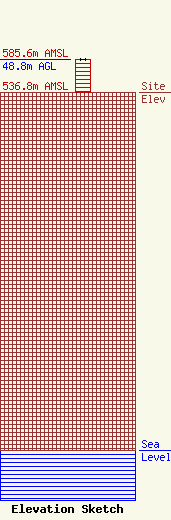
Site Elevation: 536.8 meters (1761 ft) |
| Height of Structure: 48.8 meters (160 feet) |
| Overall Height Above Ground: 48.8 meters (160 feet) |
| Overall Height Above Mean Sea Level: 585.6 meters (1921 feet) |
| Owner Info | Washington Dept of Natural Resources
1111 Washington Street
MS47042
Olympia, WA 98504-0742
(360) 902-1480
radio@dnr.wa.gov |
| Contact Info | WA-DNR Radio Operations
815 88th
47014
Tumwater, WA 98501
Tom Mahon
(360) 902-1480
tom.mahon@dnr.wa.gov |
