|
|
Antenna Structure Registration 1218101 |
 |
Registration Info | Registration Number: 1218101 |
| File Number: A0641733 |
| FAA Study: 99-ASO-1019-OE |
| FAA Issue Date: 04/16/1999 |
| Status: Constructed |
| Date Constructed: 07/15/1999 |
| FAA EMI: N |
| NEPA: N |
Structure Info
| Structure Type: TOWER |
| Structure Coordinates: 36-7-48.0 N 86-47-28.0 W (NAD 83) |
| Structure Coordinates: 36-07-47.8 N 86-47-28.0 W (Converted to NAD 27) |
| Structure Address: 2060 15th Ave South Compton |
| Structure City: Nashville, TN |
| Structure County: Davidson County |
| Painting & Lighting Info |
FAA Circular #: 70/7460-1J |
FAA Chapters: 4, 8, 13 |
Remarks: STRUCTURE REACHED GREATEST HEIGHT 7/15/99 |
Remarks: Removed expiration and final dates from determination. Scenario 2./jjs/case#635066 |
Remarks: STRUCTURE REACHED GREATEST HEIGHT 7/15/99 |
Remarks: Removed expiration and final dates from determination. Scenario 2./jjs/case#635066 |
| Elevation Info |
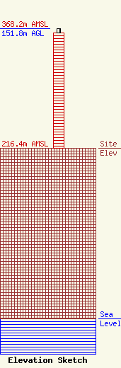
Site Elevation: 216.4 meters (710 ft) |
| Height of Structure: 146.3 meters (480 feet) |
| Overall Height Above Ground: 151.8 meters (498 feet) |
| Overall Height Above Mean Sea Level: 368.2 meters (1208 feet) |
| Owner Info | METROPOLITAN GOVT OF NASHVILLE & DAVIDSON COUNTY
PO Box 196300
Nashville, TN 37219-6300
(615) 862-5111
jody.clinard@nashville.gov |
| Info |
