|
|
Antenna Structure Registration 1218529 |
 |
Registration Info | Registration Number: 1218529 |
| File Number: A1381240 |
| FAA Study: 01-AGL-0532-OE |
| FAA Issue Date: 03/06/2001 |
| Status: Constructed |
| Date Constructed: 01/03/2002 |
| FAA EMI: N |
| NEPA: N |
Structure Info
|
| Structure Coordinates: 41-39-17.7 N 83-31-44.9 W (NAD 83) |
| Structure Coordinates: 41-39-17.5 N 83-31-45.1 W (Converted to NAD 27) |
| Structure Address: 730 N. Summit Street |
| Structure City: Toledo, OH |
| Structure County: Lucas County |
| Painting & Lighting Info |
FAA Chapters: NONE |
Remarks: PRIOR STUDY 00-AGL-6086-OE |
| Elevation Info |
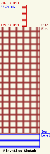
Site Elevation: 179.6 meters (589 ft) |
| Height of Structure: 36.7 meters (120 feet) |
| Overall Height Above Ground: 37.2 meters (122 feet) |
| Overall Height Above Mean Sea Level: 216.8 meters (711 feet) |
| Owner Info | WTOL Television, LLC
8401 Greensboro Drive
McLean, VA 22102
(703) 873-6600
lawdept@tegna.com |
| Contact Info | TEGNA Inc.
8401 Greensboro Drive
McLean, VA 22102
Denise Branson
(703) 873-6606
dbranson@tegna.com |
