|
|
Antenna Structure Registration 1218767 |
 |
Registration Info | Registration Number: 1218767 |
| File Number: A1276225 |
| FAA Study: 84-ASO-652-OE |
| FAA Issue Date: 04/04/1985 |
| Status: Constructed |
| Date Constructed: 10/24/2000 |
| FAA EMI: N |
| NEPA: N |
Structure Info
| Structure Type: TOWER |
| Structure Coordinates: 38-23-14.0 N 82-39-45.0 W (NAD 83) |
| Structure Coordinates: 38-23-13.7 N 82-39-45.4 W (Converted to NAD 27) |
| Structure Address: Intersection Of Musser Lane And Tarpin Road |
| Structure City: Cannonsburgh, KY |
| Structure County: Boyd County |
| Painting & Lighting Info |
FCC Paragraph(s): 1, 3, 4, 13, 21 |
Remarks: RED LIGHTS/PAINT |
| Elevation Info |
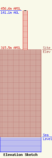
Site Elevation: 315.5 meters (1035 ft) |
| Height of Structure: 140 meters (459 feet) |
| Overall Height Above Ground: 141.1 meters (463 feet) |
| Overall Height Above Mean Sea Level: 456.6 meters (1498 feet) |
| Owner Info | Kindred Communications, Inc.
555 Fifth Avenue
Huntington, WV 25701
(304) 523-8401
mikek@kindredcom.net |
| Contact Info | Shainis & Peltzman, Chartered
1850 M Street, NW
Washington, DC 20036
Susan Marshall
(202) 293-0011
susan@s-plaw.com |
