|
|
Antenna Structure Registration 1218812 |
 |
Registration Info | Registration Number: 1218812 |
| File Number: A0817914 |
| FAA Study: 2005-AWP-5896-OE |
| FAA Issue Date: 11/07/2005 |
| Status: Constructed |
| Date Constructed: 12/15/2000 |
| FAA EMI: N |
| NEPA: N |
Structure Info
| Structure Type: TOWER |
| Structure Coordinates: 33-45-0.1 N 114-31-20.1 W (NAD 83) |
| Structure Coordinates: 33-45-00.0 N 114-31-17.3 W (Converted to NAD 27) |
| Structure Address: 87 Radio Hill (river And Hwy 95 #8811) |
| Structure City: Desert Center, CA |
| Structure County: Riverside County |
| Painting & Lighting Info |
FAA Chapters: NONE |
Remarks: PRIOR STUDY 2004-AWP-4721-OE |
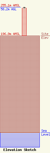
| Elevation Info |
Site Elevation: 196.9 meters (646 ft) |
| Height of Structure: 56.4 meters (185 feet) |
| Overall Height Above Ground: 58.2 meters (191 feet) |
| Overall Height Above Mean Sea Level: 255.1 meters (837 feet) |
| Owner Info | American Towers LLC
10 Presidential Way
Woburn, MA 01801
(678) 564-3236
faa-fcc@americantower.com |
| Contact Info | American Towers, LLC.
10 Presidential Way
Woburn, MA 01801
(678) 564-3236
faa-fcc@americantower.com |
