|
|
Antenna Structure Registration 1219117 |
 |
Registration Info | Registration Number: 1219117 |
| File Number: A0370153 |
| FAA Study: 00-AWP-2968-OE |
| FAA Issue Date: 10/25/2000 |
| Status: Cancelled |
| FAA EMI: N |
| NEPA: N |
Structure Info
| Structure Type: 6TA6 |
| Structure Coordinates: 34-6-53.5 N 117-59-53.7 W (NAD 83) |
| Structure Coordinates: 34-06-53.5 N 117-59-50.5 W (Converted to NAD 27) |
| Structure Address: Twr 6 Longden Ave E Of Myrtle Ave |
| Structure City: Irwindale, CA |
| Structure County: Los Angeles County |
| Painting & Lighting Info |
FAA Circular #: 70/7460-1K |
FAA Chapters: 3, 4, 5, 12 |
Remarks: PREVIOUS FAA 99-AWP-2109-OE |
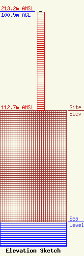
| Elevation Info |
Site Elevation: 112.7 meters (370 ft) |
| Height of Structure: 100 meters (328 feet) |
| Overall Height Above Ground: 100.5 meters (330 feet) |
| Overall Height Above Mean Sea Level: 213.2 meters (699 feet) |
| Owner Info | AMFM Ohio, Inc.
2625 S. Memorial Drive, Suite A
Tulsa, OK 74129
(918) 664-4581
FCCcontact@clearchannel.com |
| Contact Info | Clear Channel Communications, Inc.
2625 S. Memorial Drive, Suite A
Tulsa, OK 74129
Troy Langham
(918) 664-4581
troylangham@clearchannel.com |
