|
|
Antenna Structure Registration 1219448 |
 |
Registration Info | Registration Number: 1219448 |
| File Number: A1330070 |
| FAA Study: 00-AGL-6444-OE |
| FAA Issue Date: 10/18/2000 |
| Status: Constructed |
| Date Constructed: 11/26/2001 |
| FAA EMI: N |
| NEPA: N |
Structure Info
| Structure Type: TOWER |
| Structure Coordinates: 39-27-8.2 N 89-17-10.3 W (NAD 83) |
| Structure Coordinates: 39-27-08.0 N 89-17-10.0 W (Converted to NAD 27) |
| Structure Address: Appx 5 1/2 Miles Southeast Of Clarksdale Il |
| Structure City: Clarksdale, IL |
| Structure County: Christian County |
| Painting & Lighting Info |
FAA Circular #: 70/7460-1K |
FAA Chapters: 4, 6, 12 |
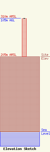
| Elevation Info |
Site Elevation: 205 meters (673 ft) |
| Height of Structure: 104 meters (341 feet) |
| Overall Height Above Ground: 105 meters (344 feet) |
| Overall Height Above Mean Sea Level: 310 meters (1017 feet) |
| Owner Info | Hart Media Group LLC
40 Woodland Trail
Rochester, IL 62563
(202) 663-8166
hartmgllc@gmail.com |
| Contact Info | Pillsbury Winthrop Shaw Pittman LLC
1200 Seventeenth Street, NW
Washington, DC 20036
Lauren Lynch Flick
(202) 663-8166
lauren.lynch.flick@pillsburylaw.com |
