|
|
Antenna Structure Registration 1220033 |
 |
Registration Info | Registration Number: 1220033 |
| File Number: A1297668 |
| FAA Study: 2010-ASO-4579-OE |
| FAA Issue Date: 09/27/2010 |
| Status: Constructed |
| Date Constructed: 06/19/2009 |
| FAA EMI: N |
| NEPA: N |
Structure Info
| Structure Type: TOWER |
| Structure Coordinates: 26-35-21.2 N 80-12-42.8 W (NAD 83) |
| Structure Coordinates: 26-35-20.0 N 80-12-43.6 W (Converted to NAD 27) |
| Structure Address: Near Intersection Of Us Hwy 441 And Lantana Road |
| Structure City: Greenacres City, FL |
| Structure County: Palm Beach County |
| Painting & Lighting Info |
FAA Circular #: 70/7460-1K |
FAA Chapters: 4, 7, 12 |
Remarks: PRIOR STUDY 2000-ASO-790-OE |
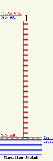
| Elevation Info |
Site Elevation: 5.5 meters (18 ft) |
| Height of Structure: 377.3 meters (1238 feet) |
| Overall Height Above Ground: 395 meters (1296 feet) |
| Overall Height Above Mean Sea Level: 400.5 meters (1314 feet) |
| Owner Info | Scripps Broadcasting Holdings LLC
312 Walnut Street
Cincinnati, OH 45202
(513) 977-3000
dave.giles@scripps.com |
| Contact Info | Baker & Hostetler LLP
1050 Connecticut Ave., NW
Washington, DC 20036
Daniel Kirkpatrick
(202) 861-1758
dkirkpatrick@bakerlaw.com |
