|
|
Antenna Structure Registration 1220049 |
 |
Registration Info | Registration Number: 1220049 |
| File Number: A1344359 |
| FAA Study: 2000-AEA-3612-OE |
| FAA Issue Date: 06/05/2003 |
| Status: Constructed |
| Date Constructed: 12/01/2003 |
| FAA EMI: N |
| NEPA: N |
Structure Info
| Structure Type: TOWER |
| Structure Coordinates: 38-10-32.5 N 79-4-11.1 W (NAD 83) |
| Structure Coordinates: 38-10-32.0 N 79-04-12.0 W (Converted to NAD 27) |
| Structure Address: 291 Woodlee Road |
| Structure City: Staunton, VA |
| Structure County: Staunton city |
| Painting & Lighting Info |
FAA Circular #: 70/7460-1K |
FAA Chapters: 4, 5, 12 |
Remarks: PRIOR STUDY 90-AEA-1185-OE |
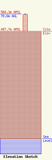
| Elevation Info |
Site Elevation: 487.7 meters (1600 ft) |
| Height of Structure: 77.7 meters (255 feet) |
| Overall Height Above Ground: 78.6 meters (258 feet) |
| Overall Height Above Mean Sea Level: 566.3 meters (1858 feet) |
| Owner Info | Vertical Bridge CC FM, LLC
22 W Atlantic Avenue
Delray Beach, FL 33444
(561) 406-4015
fcc-faa@verticalbridge.com |
| Contact Info | Vertical Bridge CC FM, LLC
22 W Atlantic Avenue
Delray Beach, FL 33444
Richard Hickey
(561) 406-4015
fcc-faa@verticalbridge.com |
