|
|
Antenna Structure Registration 1220842 |
 |
Registration Info | Registration Number: 1220842 |
| File Number: A1064894 |
| FAA Study: 2010-ASO-1418-OE |
| FAA Issue Date: 04/14/2010 |
| Status: Constructed |
| Date Constructed: 12/18/2000 |
| NEPA: N |
Structure Info
|
| Structure Coordinates: 35-15-18.3 N 87-19-30.1 W (NAD 83) |
| Structure Coordinates: 35-15-18.0 N 87-19-30.0 W (Converted to NAD 27) |
| Structure Address: 1212 N Locust Ave |
| Structure City: Lawrenceburg, TN |
| Structure County: Lawrence County |
| Painting & Lighting Info |
FCC Paragraph(s): A1, H |
Remarks: PRIOR STUDY 2000-ASO-4343-OE |
Remarks: Continue As Is OM&L = 24-HR MED-STROBES |
| Elevation Info |
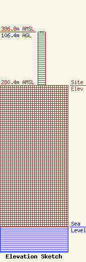
Site Elevation: 280.4 meters (920 ft) |
| Height of Structure: 106.4 meters (349 feet) |
| Overall Height Above Ground: 106.4 meters (349 feet) |
| Overall Height Above Mean Sea Level: 386.8 meters (1269 feet) |
| Info |
