|
|
Antenna Structure Registration 1222005 |
 |
Registration Info | Registration Number: 1222005 |
| File Number: A1120354 |
| FAA Study: 2018-AEA-8640-OE |
| FAA Issue Date: 06/28/2018 |
| Status: Constructed |
| Date Constructed: 11/19/2018 |
| NEPA: N |
Structure Info
| Structure Type: LTOWER |
| Structure Coordinates: 36-46-13.2 N 76-22-43.6 W (NAD 83) |
| Structure Coordinates: 36-46-12.7 N 76-22-44.8 W (Converted to NAD 27) |
| Structure Address: 3902 Military Highway South |
| Structure City: Chesapeake, VA |
| Structure County: Chesapeake city |
| Painting & Lighting Info |
FAA Circular #: 70/7460-1L |
FAA Chapters: 4, 8, 12 |
Remarks: PRIOR STUDY 2001-AEA-2023-OE |
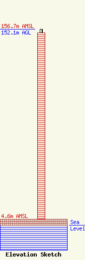
| Elevation Info |
Site Elevation: 4.6 meters (15 ft) |
| Height of Structure: 149.4 meters (490 feet) |
| Overall Height Above Ground: 152.1 meters (499 feet) |
| Overall Height Above Mean Sea Level: 156.7 meters (514 feet) |
| Owner Info | Chesapeake, City of
15225
Chesapeake, VA 23222
(757) 382-6692
BREASER@CITYOFCHESAPEAKE.NET |
| Contact Info | Department of Information Technology
300 Shea Drive
15225
Chesapeake, VA 23328
Bernard Reaser
(757) 382-6692
BREASER@CITYOFCHESAPEAKE.NET |
