|
|
Antenna Structure Registration 1222420 |
 |
Registration Info | Registration Number: 1222420 |
| File Number: A1302381 |
| FAA Study: 2024-AWP-12705-OE |
| FAA Issue Date: 10/24/2024 |
| Status: Granted |
| Date Constructed: 01/01/1966 |
Structure Info
| Structure Type: LTOWER |
| Structure Coordinates: 34-13-42.8 N 118-4-4.6 W (NAD 83) |
| Structure Coordinates: 34-13-42.8 N 118-04-01.4 W (Converted to NAD 27) |
| Structure Address: Mount Wilson (ca189a1-a) |
| Structure City: Pasadena, CA |
| Structure County: Los Angeles County |
| Painting & Lighting Info |
FAA Circular #: 70/7460-1M |
FAA Chapters: 4, 8, 15 |
Remarks: PRIOR STUDY 2001-AWP-115-OE |
| Elevation Info |
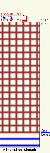
Site Elevation: 1729.4 meters (5674 ft) |
| Height of Structure: 93 meters (305 feet) |
| Overall Height Above Ground: 93 meters (305 feet) |
| Overall Height Above Mean Sea Level: 1822.4 meters (5979 feet) |
| Owner Info | SBA Towers XI, LLC
8051 Congress Avenue
Boca Raton, FL 33487
(561) 995-7670
ERoach@sbasite.com |
| Contact Info | SBA Towers XI, LLC
8051 Congress Avenue
Boca Raton, FL 33487
(561) 995-7670
ERoach@sbasite.com |
