|
|
Antenna Structure Registration 1223919 |
 |
Registration Info | Registration Number: 1223919 |
| File Number: A1082350 |
| FAA Study: 2017-ASO-11194-OE |
| FAA Issue Date: 06/08/2017 |
| Status: Constructed |
| Date Constructed: 06/22/2017 |
| NEPA: N |
Structure Info
| Structure Type: LTOWER |
| Structure Coordinates: 36-10-37.3 N 86-46-41.2 W (NAD 83) |
| Structure Coordinates: 36-10-37.1 N 86-46-41.2 W (Converted to NAD 27) |
| Structure Address: 19 Oldham Street |
| Structure City: Nashville, TN |
| Structure County: Davidson County |
| Painting & Lighting Info |
FAA Circular #: 70/7460-1L |
FAA Chapters: 4, 8, 12 |
Remarks: PRIOR STUDY 2000-ASO-2123-OE |
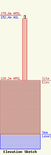
| Elevation Info |
Site Elevation: 126.2 meters (414 ft) |
| Height of Structure: 144.8 meters (475 feet) |
| Overall Height Above Ground: 152.4 meters (500 feet) |
| Overall Height Above Mean Sea Level: 278.6 meters (914 feet) |
| Owner Info | Subcarrier Communications Inc
139 White Oak Lane
Old Bridge, NJ 08857
(732) 607-2828
subcom1@subcarrier.com |
| Contact Info | Subcarrier Communications Inc
139 White Oak Lane
Old Bridge, NJ 08857
John Paleski
(732) 607-2828
subcom1@subcarrier.com |
