|
|
Antenna Structure Registration 1223959 |
 |
Registration Info | Registration Number: 1223959 |
| File Number: A1262401 |
| FAA Study: 2022-ASW-6773-OE |
| FAA Issue Date: 01/17/2023 |
| Status: Constructed |
| Date Constructed: 05/08/2001 |
| NEPA: N |
Structure Info
| Structure Type: LTOWER |
| Structure Coordinates: 29-47-26.8 N 95-20-43.4 W (NAD 83) |
| Structure Coordinates: 29-47-26.0 N 95-20-42.6 W (Converted to NAD 27) |
| Structure Address: 2949 2/3 Carr Street (374516) |
| Structure City: Houston, TX |
| Structure County: Harris County |
| Painting & Lighting Info |
FAA Circular #: 70/7460-1K |
FAA Chapters: 4, 8, 12 |
Remarks: PRIOR STUDY 2000-ASW-4705-OE |
Remarks: OM&L to remain the same as prior study = A MED-DUAL SYSTEM |
Remarks: PRIOR STUDY 2000-ASW-4705-OE |
Remarks: OM&L to remain the same as prior study = A MED-DUAL SYSTEM |
| Elevation Info |
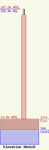
Site Elevation: 14.9 meters (49 ft) |
| Height of Structure: 144.5 meters (474 feet) |
| Overall Height Above Ground: 152.4 meters (500 feet) |
| Overall Height Above Mean Sea Level: 167.3 meters (549 feet) |
| Owner Info | American Towers LLC
10 Presidential Way
Woburn, MA 01801
(781) 926-4500
faa-fcc@americantower.com |
| Contact Info | American Towers LLC
10 Presidential Way
Woburn, MA 01801
(781) 926-4500
faa-fcc@americantower.com |
