|
|
Antenna Structure Registration 1224014 |
 |
Registration Info | Registration Number: 1224014 |
| File Number: A0254061 |
| FAA Study: 93-ASO-0391-OE |
| FAA Issue Date: 04/13/1993 |
| Status: Constructed |
| Date Constructed: 05/01/1993 |
| FAA EMI: N |
| NEPA: N |
Structure Info
| Structure Type: TOWER |
| Structure Coordinates: 36-6-47.2 N 84-8-31.7 W (NAD 83) |
| Structure Coordinates: 36-06-46.9 N 84-08-32.0 W (Converted to NAD 27) |
| Structure Address: Spring Street |
| Structure City: Clinton, TN |
| Structure County: Anderson County |
| Painting & Lighting Info |
FAA Circular #: 70/7460-1H |
FAA Chapters: 3, 4, 5, 13 |
| Elevation Info |
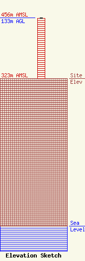
Site Elevation: 323 meters (1060 ft) |
| Height of Structure: 132 meters (433 feet) |
| Overall Height Above Ground: 133 meters (436 feet) |
| Overall Height Above Mean Sea Level: 456 meters (1496 feet) |
| Owner Info | Clinton Broadcasters, Inc.
329
Clinton, TN 37717
(865) 457-1380
|
| Info |
