|
|
Antenna Structure Registration 1224095 |
 |
Registration Info | Registration Number: 1224095 |
| File Number: A0910033 |
| FAA Study: 01-AEA-0190-OE |
| FAA Issue Date: 03/06/2001 |
| Status: Constructed |
| Date Constructed: 06/09/1953 |
| FAA EMI: N |
| NEPA: N |
Structure Info
| Structure Type: TOWER |
| Structure Coordinates: 40-57-36.0 N 79-0-7.1 W (NAD 83) |
| Structure Coordinates: 40-57-35.8 N 79-00-08.0 W (Converted to NAD 27) |
| Structure Address: Off Rt. 36 1 Mile North Of Punxsutawney, Pa |
| Structure City: Punxsutawney, PA |
| Structure County: Jefferson County |
| Painting & Lighting Info |
FCC Paragraph(s): 1, 3, 11, 21 |
Remarks: RED LIGHTS/PAINT. |
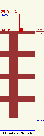
| Elevation Info |
Site Elevation: 461.8 meters (1515 ft) |
| Height of Structure: 95.1 meters (312 feet) |
| Overall Height Above Ground: 96.9 meters (318 feet) |
| Overall Height Above Mean Sea Level: 558.7 meters (1833 feet) |
| Owner Info | Renda Radio
900 Parish Street
Pittsburgh, PA 15220
(412) 875-1800
fcccontact@rendabroadcasting.com |
| Contact Info | Renda Radio WPXZ
904 North Main Street
Punxsutawney, PA 15767
Jason Horvath
(814) 938-6000
fcccontact@rendabroadcasting.com |
