|
|
Antenna Structure Registration 1224717 |
 |
Registration Info | Registration Number: 1224717 |
| File Number: A0983098 |
| FAA Study: 01-ASO-0583-OE |
| FAA Issue Date: 03/12/2001 |
| Status: Constructed |
| Date Constructed: 11/14/2005 |
| FAA EMI: N |
| NEPA: N |
Structure Info
| Structure Type: TOWER |
| Structure Coordinates: 34-50-19.4 N 82-21-45.4 W (NAD 83) |
| Structure Coordinates: 34-50-19.0 N 82-21-46.0 W (Converted to NAD 27) |
| Structure Address: Hwy 291 & East Antrim Road |
| Structure City: Greenvile, SC |
| Structure County: Greenville County |
| Painting & Lighting Info |
FAA Chapters: NONE |
Remarks: Removed expiration date from determination. Scenario 1./jjs/case#635066 |
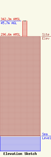
| Elevation Info |
Site Elevation: 296.6 meters (973 ft) |
| Height of Structure: 45.7 meters (150 feet) |
| Overall Height Above Ground: 45.7 meters (150 feet) |
| Overall Height Above Mean Sea Level: 342.3 meters (1123 feet) |
| Owner Info | TBLC GREENSBORO STATIONS, LLC
4601 NOLENSVILLE ROAD
NASHVILLE, TN 37221
(615) 242-1411
THOMAS@TBLCMEDIA.COM |
| Contact Info | RADIOTVLAW ASSOCIATES, LLC
4101 Albemarle St. NW #324
Washington, DC 20016-2151
Anthony Lepore
(202) 681-2201
anthony@radiotvlaw.net |
