|
|
Antenna Structure Registration 1226168 |
 |
Registration Info | Registration Number: 1226168 |
| File Number: A1083993 |
| FAA Study: 01-AGL-0163-OE |
| Status: Constructed |
| Date Constructed: 10/05/2001 |
| FAA EMI: N |
| NEPA: N |
Structure Info
|
| Structure Coordinates: 41-9-4.2 N 81-20-12.7 W (NAD 83) |
| Structure Coordinates: 41-09-04.0 N 81-20-13.3 W (Converted to NAD 27) |
| Structure Address: 500 East Main Street |
| Structure City: Kent, OH |
| Structure County: Portage County |
| Painting & Lighting Info |
FAA Circular #: 70/7460-1K |
FAA Chapters: 4, 8, 12 |
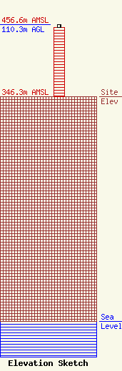
| Elevation Info |
Site Elevation: 346.3 meters (1136 ft) |
| Height of Structure: 106.7 meters (350 feet) |
| Overall Height Above Ground: 110.3 meters (362 feet) |
| Overall Height Above Mean Sea Level: 456.6 meters (1498 feet) |
| Owner Info | Kent State University
1613 East Summit Street
5190
Kent, OH 44242
(330) 672-9164
poulton@wksu.org |
| Contact Info | PSS Telecom Management
911
Kent, OH 44240
R Patterson
(330) 677-0911
r.m.patterson@commtower.com |
