|
|
Antenna Structure Registration 1226223 |
 |
Registration Info | Registration Number: 1226223 |
| File Number: A0553305 |
| FAA Study: 01-ACE-0547-OE |
| FAA Issue Date: 03/28/2001 |
| Status: Constructed |
| Date Constructed: 09/28/2001 |
| FAA EMI: N |
| NEPA: N |
Structure Info
| Structure Type: TOWER |
| Structure Coordinates: 38-40-53.2 N 90-12-1.9 W (NAD 83) |
| Structure Coordinates: 38-40-53.0 N 90-12-01.5 W (Converted to NAD 27) |
| Structure Address: 239 Prairie |
| Structure City: St. Louis, MO |
| Structure County: St. Louis city |
| Painting & Lighting Info |
FAA Circular #: 70/7460-1K |
FAA Chapters: 4, 8, 12 |
Remarks: Removed expiration date from determination. Scenario 1./jjs/case#635066 |
Remarks: PRIOR STUDY 00-ACE-1980-OE SUPPLEMENTAL NOTICE STATES STRUCTURE REACHED GREATEST HEIGHT ON 09/28/2001 |
Remarks: Removed expiration date from determination. Scenario 1./jjs/case#635066 |
Remarks: PRIOR STUDY 00-ACE-1980-OE SUPPLEMENTAL NOTICE STATES STRUCTURE REACHED GREATEST HEIGHT ON 09/28/2001 |
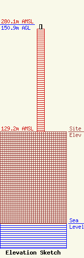
| Elevation Info |
Site Elevation: 129.2 meters (424 ft) |
| Height of Structure: 144.7 meters (475 feet) |
| Overall Height Above Ground: 150.9 meters (495 feet) |
| Overall Height Above Mean Sea Level: 280.1 meters (919 feet) |
| Owner Info | Subcarrier Communications Inc
139 White Oak Lane
Old Bridge, NJ 08857
(732) 607-2828
subcom1@subcarrier.com |
| Contact Info | Subcarrier Communications Inc
139 White Oak Lane
Old Bridge, NJ 08857
John Paleski
(732) 607-2828
subcom1@subcarrier.com |
