|
|
Antenna Structure Registration 1226360 |
 |
Registration Info | Registration Number: 1226360 |
| File Number: A1063907 |
| FAA Study: 01-AEA-0721-OE |
| FAA Issue Date: 06/04/2001 |
| Status: Constructed |
| Date Constructed: 10/30/2002 |
| FAA EMI: N |
| NEPA: N |
Structure Info
| Structure Type: TOWER |
| Structure Coordinates: 40-22-17.0 N 78-58-55.0 W (NAD 83) |
| Structure Coordinates: 40-22-16.7 N 78-58-55.9 W (Converted to NAD 27) |
| Structure Address: Laurel Hill |
| Structure City: Morrellville, PA |
| Structure County: Cambria County |
| Painting & Lighting Info |
FAA Circular #: 70/7460-1K |
FAA Chapters: 4, 6, 12 |
Remarks: Removed expiration date from determination. Scenario 1./jjs/case#635066 |
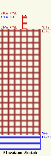
| Elevation Info |
Site Elevation: 810 meters (2657 ft) |
| Height of Structure: 108 meters (354 feet) |
| Overall Height Above Ground: 108 meters (354 feet) |
| Overall Height Above Mean Sea Level: 918 meters (3012 feet) |
| Owner Info | Sinclair Television of Fresno, LLC
Pillsbury Winthrop Shaw Pittman LLP
Washington, DC 20036
(202) 663-8195
miles.mason@pillsburylaw.com |
| Contact Info | Sinclair Television of Fresno, LLC
Pillsbury Winthrop Shaw Pittman LLP
Washington, DC 20036
(202) 663-8195
miles.mason@pillsburylaw.com |
