|
|
Antenna Structure Registration 1226843 |
 |
Registration Info | Registration Number: 1226843 |
| File Number: A0197461 |
| FAA Study: 01-AEA-0902-OE |
| FAA Issue Date: 06/01/2001 |
| Status: Granted |
| NEPA: N |
Structure Info
| Structure Type: TOWER |
| Structure Coordinates: 38-56-59.8 N 77-4-46.7 W (NAD 83) |
| Structure Coordinates: 38-56-59.4 N 77-04-47.8 W (Converted to NAD 27) |
| Structure Address: 4001 Brandywine, Nw |
| Structure City: Washington, DC |
| Structure County: District of Columbia |
| Painting & Lighting Info |
FAA Circular #: 70/7460-1K |
FAA Chapters: 3, 4, 5, 12 |
| Elevation Info |
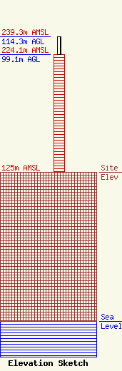
Site Elevation: 125 meters (410 ft) |
| Height of Structure: 99.1 meters (325 feet) |
| Overall Height Above Ground: 114.3 meters (375 feet) |
| Overall Height Above Mean Sea Level: 239.3 meters (785 feet) |
| Owner Info | Douglas Development Corporation
702 H Street, NW, Suite 400
Washington, DC 20001
(202) 638-6300
njemal@douglasdev.com |
| Contact Info | Wireless Development Corporation
3 Weatherly Drive, #204
Mill Valley, CA 94941
Michael Fischer
(800) 910-8953
wirelessdevelop@hotmail.com |
