|
|
Antenna Structure Registration 1226929 |
 |
Registration Info | Registration Number: 1226929 |
| File Number: A0284904 |
| FAA Study: 01-ACE-0665-OE |
| FAA Issue Date: 05/02/2001 |
| Status: Constructed |
| Date Constructed: 06/26/2001 |
| FAA EMI: N |
| NEPA: N |
Structure Info
| Structure Type: TOWER |
| Structure Coordinates: 36-35-59.6 N 93-14-34.6 W (NAD 83) |
| Structure Coordinates: 36-35-59.4 N 93-14-33.9 W (Converted to NAD 27) |
| Structure Address: 118 State Street |
| Structure City: Hollister, MO |
| Structure County: Taney County |
| Painting & Lighting Info |
FAA Chapters: NONE |
Remarks: Removed expiration date from determination. Scenario 1./jjs/case#635066 |
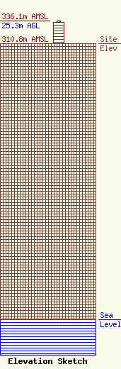
| Elevation Info |
Site Elevation: 310.8 meters (1020 ft) |
| Height of Structure: 24.4 meters (80 feet) |
| Overall Height Above Ground: 25.3 meters (83 feet) |
| Overall Height Above Mean Sea Level: 336.1 meters (1103 feet) |
| Owner Info | R.S. COMMUNICATIONS LTD. PARTNERSHIP
2535 SUCCESS DRIVE
ODESSA, FL 33556
(727) 372-8808
RWBAKERCPA@COMPUSERVE.COM |
| Contact Info | PINZONE ENGINEERING GROUP, INC.
10142 FAIRMOUNT ROAD
NEWBURY, OH 44065
BASIL PINZONE
(304) 284-7615
PINZONE@CONCENTRIC.NET |
