|
|
Antenna Structure Registration 1227380 |
 |
Registration Info | Registration Number: 1227380 |
| File Number: A0200196 |
| FAA Study: 94-ANM-0022-OE |
| FAA Issue Date: 01/07/1994 |
| Status: Granted |
| NEPA: N |
Structure Info
| Structure Type: TOWER |
| Structure Coordinates: 37-3-48.9 N 113-34-22.8 W (NAD 83) |
| Structure Coordinates: 37-03-49.0 N 113-34-20.0 W (Converted to NAD 27) |
| Structure Address: Webb Hill |
| Structure City: St. George, UT |
| Structure County: Washington County |
| Painting & Lighting Info |
FAA Chapters: NONE |
| Elevation Info |
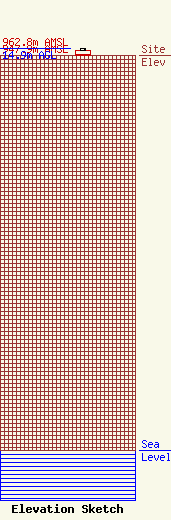
Site Elevation: 947.9 meters (3110 ft) |
| Height of Structure: 12.1 meters (40 feet) |
| Overall Height Above Ground: 14.9 meters (49 feet) |
| Overall Height Above Mean Sea Level: 962.8 meters (3159 feet) |
| Owner Info | TSM, Inc.
845 East Skyline
1207
St. George, UT 84770
(435) 673-0203
ray@skyviewtech.com |
| Info |
