|
|
Antenna Structure Registration 1227878 |
 |
Registration Info | Registration Number: 1227878 |
| File Number: A0279338 |
| FAA Study: 01-AWP-2056-OE |
| FAA Issue Date: 06/19/2001 |
| Status: Constructed |
| Date Constructed: 06/01/1965 |
| FAA EMI: N |
| NEPA: N |
Structure Info
| Structure Type: TOWER |
| Structure Coordinates: 37-4-22.1 N 119-25-56.0 W (NAD 83) |
| Structure Coordinates: 37-04-22.3 N 119-25-52.5 W (Converted to NAD 27) |
| Structure Address: 42001 Radio Lane |
| Structure City: Auberry, CA |
| Structure County: Fresno County |
| Painting & Lighting Info |
FAA Circular #: 70/7460-1K |
FAA Chapters: 3, 4, 5, 12 |
| Elevation Info |
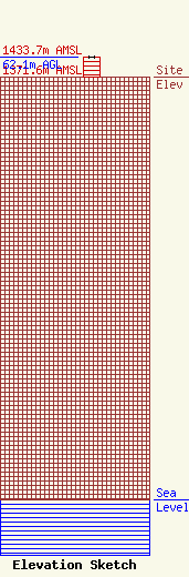
Site Elevation: 1371.6 meters (4500 ft) |
| Height of Structure: 62.1 meters (204 feet) |
| Overall Height Above Ground: 62.1 meters (204 feet) |
| Overall Height Above Mean Sea Level: 1433.7 meters (4704 feet) |
| Info |
| Contact Info | Dean Tower
404 E. Lester Ave
25085
Fresno, CA 93729
Scott Dean
(559) 434-2358
deeng@mediaone.net |
