|
|
Antenna Structure Registration 1227937 |
 |
Registration Info | Registration Number: 1227937 |
| File Number: A1241290 |
| FAA Study: 2022-ASW-22511-OE |
| FAA Issue Date: 03/30/2023 |
| Status: Constructed |
| Date Constructed: 03/16/2001 |
| NEPA: N |
Structure Info
| Structure Type: MTOWER |
| Structure Coordinates: 34-46-1.3 N 92-23-49.8 W (NAD 83) |
| Structure Coordinates: 34-46-01.0 N 92-23-49.2 W (Converted to NAD 27) |
| Structure Address: 1428 Merrill Drive (ar04990-a) |
| Structure City: Little Rock, AR |
| Structure County: Pulaski County |
| Painting & Lighting Info |
FAA Chapters: NONE |
Remarks: PRIOR STUDY 2022-ASW-20130-OE |
| Elevation Info |
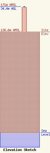
Site Elevation: 136.6 meters (448 ft) |
| Height of Structure: 33.5 meters (110 feet) |
| Overall Height Above Ground: 34.4 meters (113 feet) |
| Overall Height Above Mean Sea Level: 171 meters (561 feet) |
| Owner Info | SBA Properties, LLC
8051 Congress Avenue
Boca Raton, FL 33487
(561) 995-7670
ERoach@sbasite.com |
| Contact Info | SBA Properties, LLC
8051 Congress Avenue
Boca Raton, FL 33487
(561) 995-7670
ERoach@sbasite.com |
