|
|
Antenna Structure Registration 1227945 |
 |
Registration Info | Registration Number: 1227945 |
| File Number: A1242840 |
| FAA Study: 2022-ASW-1149-OE |
| FAA Issue Date: 11/03/2022 |
| Status: Constructed |
| Date Constructed: 03/16/2001 |
| NEPA: N |
Structure Info
| Structure Type: MTOWER |
| Structure Coordinates: 34-42-54.1 N 92-23-56.9 W (NAD 83) |
| Structure Coordinates: 34-42-53.8 N 92-23-56.3 W (Converted to NAD 27) |
| Structure Address: 10750 Colonel Glenn Road (ar04942-a) |
| Structure City: Little Rock, AR |
| Structure County: Pulaski County |
| Painting & Lighting Info |
FAA Chapters: NONE |
Remarks: PRIOR STUDY 2001-ASW-3890-OE |
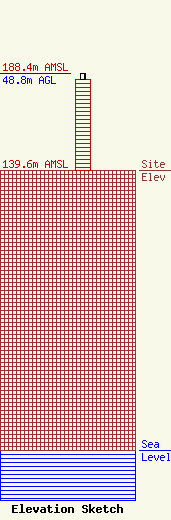
| Elevation Info |
Site Elevation: 139.6 meters (458 ft) |
| Height of Structure: 45.7 meters (150 feet) |
| Overall Height Above Ground: 48.8 meters (160 feet) |
| Overall Height Above Mean Sea Level: 188.4 meters (618 feet) |
| Owner Info | SBA Properties, LLC
8051 Congress Avenue
Boca Raton, FL 33487
(561) 995-7670
ERoach@sbasite.com |
| Contact Info | SBA Properties, LLC
8051 Congress Avenue
Boca Raton, FL 33487
(561) 995-7670
ERoach@sbasite.com |
