|
|
Antenna Structure Registration 1228110 |
 |
Registration Info | Registration Number: 1228110 |
| File Number: A0939802 |
| FAA Study: 01-ASO-3237-OE |
| FAA Issue Date: 06/25/2001 |
| Status: Constructed |
| Date Constructed: 04/11/2002 |
| FAA EMI: N |
| NEPA: N |
Structure Info
| Structure Type: TOWER |
| Structure Coordinates: 34-41-46.2 N 81-1-22.9 W (NAD 83) |
| Structure Coordinates: 34-41-45.7 N 81-01-23.6 W (Converted to NAD 27) |
| Structure Address: West Side Of Sc 901 2 Kilometers South Of Richburg, Sc |
| Structure City: Richburg, SC |
| Structure County: Chester County |
| Painting & Lighting Info |
FAA Circular #: 70/7460-1K |
FAA Chapters: 4, 6, 12 |
Remarks: Removed expiration date from determination. Scenario 1./jjs/case#635066 |
Remarks: SUPPLEMENTAL NOTICE STATES STRUCTURE REACHED GREATEST HEIGHT ON 04/11/2002 |
Remarks: Removed expiration date from determination. Scenario 1./jjs/case#635066 |
Remarks: SUPPLEMENTAL NOTICE STATES STRUCTURE REACHED GREATEST HEIGHT ON 04/11/2002 |
| Elevation Info |
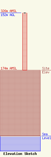
Site Elevation: 174 meters (571 ft) |
| Height of Structure: 151 meters (495 feet) |
| Overall Height Above Ground: 152 meters (499 feet) |
| Overall Height Above Mean Sea Level: 326 meters (1070 feet) |
| Info |
| Contact Info | Jeffrey C. Sigmon, Sr.
258
York, SC 29745
Jeffrey Sigmon
(803) 372-7450
jefco@rhtc.net |
