|
|
Antenna Structure Registration 1228276 |
 |
Registration Info | Registration Number: 1228276 |
| File Number: A1175591 |
| FAA Study: 01-AGL-0305-OE |
| FAA Issue Date: 02/16/2001 |
| Status: Dismantled |
| Date Constructed: 02/02/2002 |
| FAA EMI: N |
| NEPA: N |
Structure Info
| Structure Type: POLE |
| Structure Coordinates: 46-50-36.1 N 96-47-10.9 W (NAD 83) |
| Structure Coordinates: 46-50-36.2 N 96-47-09.6 W (Converted to NAD 27) |
| Structure Address: 2410 5th St S |
| Structure City: Fargo, ND |
| Structure County: Cass County |
| Painting & Lighting Info |
FAA Chapters: NONE |
| Elevation Info |
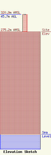
Site Elevation: 275.2 meters (903 ft) |
| Height of Structure: 45.7 meters (150 feet) |
| Overall Height Above Ground: 45.7 meters (150 feet) |
| Overall Height Above Mean Sea Level: 320.9 meters (1053 feet) |
| Owner Info | GREAT PLAINS TOWER PROPERTIES LLP
4625 45 Street South Suite 200
FARGO, ND 58104
(701) 282-2236
KReski@GreatPlainsTowers.com |
| Contact Info | Great PLains Tower Properties, LLP
4265 45 Street South / Suite 200
Fargo, ND 58104
Kevin Reski
(701) 282-2236
KReski@GreatPlainsTowers.com |
