|
|
Antenna Structure Registration 1228972 |
 |
Registration Info | Registration Number: 1228972 |
| File Number: A1273200 |
| FAA Study: 2022-ASW-1162-OE |
| FAA Issue Date: 11/21/2022 |
| Status: Constructed |
| Date Constructed: 03/16/2001 |
| NEPA: N |
Structure Info
| Structure Type: MTOWER |
| Structure Coordinates: 34-46-5.6 N 92-25-41.4 W (NAD 83) |
| Structure Coordinates: 34-46-05.3 N 92-25-40.8 W (Converted to NAD 27) |
| Structure Address: 13625 Saddle Hill Drive (ar05035-a) |
| Structure City: Little Rock, AR |
| Structure County: Pulaski County |
| Painting & Lighting Info |
FAA Chapters: NONE |
Remarks: PRIOR STUDY 2007-ASW-11359-OE |
| Elevation Info |
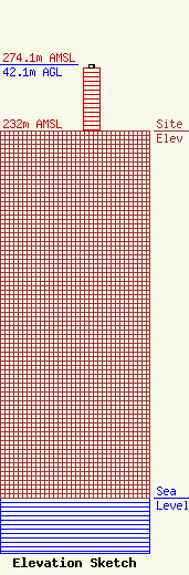
Site Elevation: 232 meters (761 ft) |
| Height of Structure: 39.9 meters (131 feet) |
| Overall Height Above Ground: 42.1 meters (138 feet) |
| Overall Height Above Mean Sea Level: 274.1 meters (899 feet) |
| Owner Info | SBA Properties, LLC
8051 Congress Avenue
Boca Raton, FL 33487
(561) 995-7670
ERoach@sbasite.com |
| Contact Info | SBA Properties, LLC
8051 Congress Avenue
Boca Raton, FL 33487
(561) 995-7670
ERoach@sbasite.com |
