|
|
Antenna Structure Registration 1228980 |
 |
Registration Info | Registration Number: 1228980 |
| File Number: A1242846 |
| FAA Study: 2022-ASW-1152-OE |
| FAA Issue Date: 11/03/2022 |
| Status: Constructed |
| Date Constructed: 09/21/2001 |
| NEPA: N |
Structure Info
| Structure Type: MTOWER |
| Structure Coordinates: 34-44-49.7 N 92-25-11.4 W (NAD 83) |
| Structure Coordinates: 34-44-49.4 N 92-25-10.8 W (Converted to NAD 27) |
| Structure Address: 701 Nix Road (ar04976-a) |
| Structure City: Little Rock, AR |
| Structure County: Pulaski County |
| Painting & Lighting Info |
FAA Chapters: NONE |
Remarks: PRIOR STUDY 2001-ASW-3886-OE |
| Elevation Info |
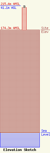
Site Elevation: 174.3 meters (572 ft) |
| Height of Structure: 38.1 meters (125 feet) |
| Overall Height Above Ground: 41.1 meters (135 feet) |
| Overall Height Above Mean Sea Level: 215.4 meters (707 feet) |
| Owner Info | SBA Properties, LLC
8051 Congress Avenue
Boca Raton, FL 33487
(561) 995-7670
ERoach@sbasite.com |
| Contact Info | SBA Properties, LLC
8051 Congress Avenue
Boca Raton, FL 33487
(561) 995-7670
ERoach@sbasite.com |
