|
|
Antenna Structure Registration 1228985 |
 |
Registration Info | Registration Number: 1228985 |
| File Number: A0834311 |
| FAA Study: 01-ASW-3913-OE |
| FAA Issue Date: 08/17/2001 |
| Status: Constructed |
| Date Constructed: 03/16/2001 |
| FAA EMI: N |
| NEPA: N |
Structure Info
| Structure Type: TOWER |
| Structure Coordinates: 34-53-13.1 N 92-23-1.9 W (NAD 83) |
| Structure Coordinates: 34-53-12.8 N 92-23-01.3 W (Converted to NAD 27) |
| Structure Address: 14421 C Frontier Drive |
| Structure City: North Little Rock, AR |
| Structure County: Pulaski County |
| Painting & Lighting Info |
FAA Chapters: NONE |
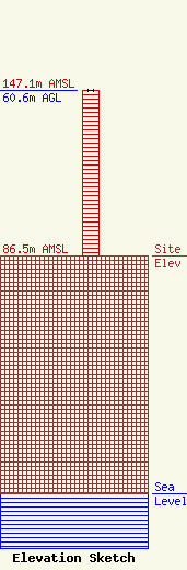
| Elevation Info |
Site Elevation: 86.5 meters (284 ft) |
| Height of Structure: 60.6 meters (199 feet) |
| Overall Height Above Ground: 60.6 meters (199 feet) |
| Overall Height Above Mean Sea Level: 147.1 meters (483 feet) |
| Owner Info | SBA Properties, LLC
8051 Congress Avenue
Boca Raton, FL 33487
(561) 995-7670
ERoach@sbasite.com |
| Contact Info | SBA Properties, LLC
8051 Congress Avenue
Boca Raton, FL 33487
Edward Roach
(561) 995-7670
ERoach@sbasite.com |
