|
|
Antenna Structure Registration 1229002 |
 |
Registration Info | Registration Number: 1229002 |
| File Number: A0607135 |
| FAA Study: 01-ANM-2583-OE |
| FAA Issue Date: 08/15/2001 |
| Status: Constructed |
| Date Constructed: 10/16/2000 |
| FAA EMI: N |
| NEPA: N |
Structure Info
| Structure Type: TOWER |
| Structure Coordinates: 42-24-42.5 N 123-16-58.5 W (NAD 83) |
| Structure Coordinates: 42-24-43.1 N 123-16-54.3 W (Converted to NAD 27) |
| Structure Address: Town Of Applegate, Or |
| Structure City: Applegate, OR |
| Structure County: Josephine County |
| Painting & Lighting Info |
FAA Circular #: 70/7460-1K |
FAA Chapters: 4, 5, 12 |
Remarks: Removed expiration date from determination. Scenario 1./jjs/case#635066 |
| Elevation Info |
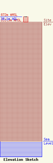
Site Elevation: 833.9 meters (2736 ft) |
| Height of Structure: 38.1 meters (125 feet) |
| Overall Height Above Ground: 38.1 meters (125 feet) |
| Overall Height Above Mean Sea Level: 872 meters (2861 feet) |
| Owner Info | CALIFORNIA OREGON BROADCASTING, INC
125 S FIR STREET
1489
MEDFORD, OR 97501
PATRICIA SMULLIN
(541) 779-9520
cobiadmin@kobi5.com |
| Info |
