|
|
Antenna Structure Registration 1229155 |
 |
Registration Info | Registration Number: 1229155 |
| File Number: A0269982 |
| FAA Study: 01-ASO-5132-OE |
| FAA Issue Date: 08/27/2001 |
| Status: Constructed |
| Date Constructed: 06/15/2002 |
| FAA EMI: N |
| NEPA: N |
Structure Info
| Structure Type: TOWER |
| Structure Coordinates: 30-8-49.0 N 81-31-50.3 W (NAD 83) |
| Structure Coordinates: 30-08-48.1 N 81-31-51.0 W (Converted to NAD 27) |
| Structure Address: 14247 Old St. Augustine Rd. |
| Structure City: Jacksonville, FL |
| Structure County: Duval County |
| Painting & Lighting Info |
FAA Circular #: 70/7460-1K |
FAA Chapters: 4, 8, 12 |
Remarks: SUPPLEMENTAL NOTICE STATES STRUCTURE REACHED GREATEST HEIGHT ON 06/15/2002 |
Remarks: Removed expiration date from determination. Scenario 1./jjs/case#635066 |
Remarks: SUPPLEMENTAL NOTICE STATES STRUCTURE REACHED GREATEST HEIGHT ON 06/15/2002 |
Remarks: Removed expiration date from determination. Scenario 1./jjs/case#635066 |
| Elevation Info |
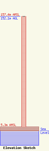
Site Elevation: 5.3 meters (17 ft) |
| Height of Structure: 152.1 meters (499 feet) |
| Overall Height Above Ground: 152.1 meters (499 feet) |
| Overall Height Above Mean Sea Level: 157.4 meters (516 feet) |
| Owner Info | JEA
21 WEST CHURCH STREET
JACKS0NVILLE, FL 32202
Michael Key
(904) 665-8888
JEAFCC@JEA.COM |
| Contact Info | JEA
21 WEST CHURCH STREET
JACKSONVILLE, FL 32202
MICHAEL KEY
(904) 665-8888
JEAFCC@JEA.COM |
