|
|
Antenna Structure Registration 1229622 |
 |
Registration Info | Registration Number: 1229622 |
| File Number: A1050706 |
| FAA Study: 2012-AGL-6979-OE |
| FAA Issue Date: 10/23/2012 |
| Status: Constructed |
| Date Constructed: 09/15/2003 |
| FAA EMI: N |
| NEPA: N |
Structure Info
| Structure Type: GTOWER |
| Structure Coordinates: 43-45-5.1 N 85-12-46.2 W (NAD 83) |
| Structure Coordinates: 43-45-05.0 N 85-12-46.1 W (Converted to NAD 27) |
| Structure Address: Three Miles West Of Barryton, Michigan On County Road 65 |
| Structure City: Barryton, MI |
| Structure County: Mecosta County |
| Painting & Lighting Info |
FAA Circular #: 70/7460-1K |
FAA Chapters: 4, 7, 12 |
Remarks: PRIOR STUDY 2001-AGL-362-OE |
Remarks: OM&L to remain the same as prior study = 24-HR HI-STROBES |
Remarks: Continue As Is OM&L = PAINT/RED LIGHTS |
Remarks: PRIOR STUDY 2001-AGL-362-OE |
Remarks: OM&L to remain the same as prior study = 24-HR HI-STROBES |
| Elevation Info |
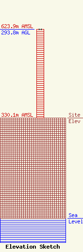
Site Elevation: 330.1 meters (1083 ft) |
| Height of Structure: 292.9 meters (961 feet) |
| Overall Height Above Ground: 293.8 meters (964 feet) |
| Overall Height Above Mean Sea Level: 623.9 meters (2047 feet) |
| Owner Info | CMU Public Broadcasting
1999 East Campus Drive
Mt. Pleasant, MI 48859
(989) 774-3105
wayne.h@cmich.edu |
| Contact Info | CMU Public Broadcasting
1999 East Campus Drive
Mt. Pleasant, MI 48859
(989) 774-3105
wayne.h@cmich.edu |
