|
|
Antenna Structure Registration 1230898 |
 |
Registration Info | Registration Number: 1230898 |
| File Number: A1075526 |
| FAA Study: 01-AGL-6408-OE |
| FAA Issue Date: 09/17/2001 |
| Status: Granted |
| NEPA: N |
Structure Info
| Structure Type: TOWER |
| Structure Coordinates: 43-10-33.1 N 86-12-43.2 W (NAD 83) |
| Structure Coordinates: 43-10-33.0 N 86-12-43.0 W (Converted to NAD 27) |
| Structure Address: 4237 Airline Drive |
| Structure City: Norton Shores, MI |
| Structure County: Muskegon County |
| Painting & Lighting Info |
FAA Circular #: |
FAA Chapters: NONE |
Remarks: Removed expiration date from determination. Scenario 1./jjs/case#635066 |
Remarks: PRIOR STUDY 92-AGL-1013-OE |
Remarks: Removed expiration date from determination. Scenario 1./jjs/case#635066 |
| Elevation Info |
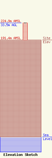
Site Elevation: 191.4 meters (628 ft) |
| Height of Structure: 33.5 meters (110 feet) |
| Overall Height Above Ground: 33.5 meters (110 feet) |
| Overall Height Above Mean Sea Level: 224.9 meters (738 feet) |
| Owner Info | WMKG-TV, LLC
4237 Airline Road
Norton Shores, MI 49441
(561) 948-0950
legal@vrvc.com |
| Contact Info | Koerner & Olender, P.C.
7020 Richard Drive
Bethesda, MD 20817
James Koerner
(301) 468-3336
jkoerner.law@comcast.net |
