|
|
Antenna Structure Registration 1231373 |
 |
Registration Info | Registration Number: 1231373 |
| File Number: A1085114 |
| FAA Study: 01-ASW-0151-OE |
| FAA Issue Date: 02/26/2001 |
| Status: Constructed |
| Date Constructed: 10/05/2001 |
| FAA EMI: N |
| NEPA: N |
Structure Info
| Structure Type: TOWER |
| Structure Coordinates: 33-7-24.4 N 94-57-45.0 W (NAD 83) |
| Structure Coordinates: 33-07-24.0 N 94-57-44.2 W (Converted to NAD 27) |
| Structure Address: County Road Se 1, 1 Mile East Of City Limits |
| Structure City: Mount Pleasant, TX |
| Structure County: Titus County |
| Painting & Lighting Info |
FAA Chapters: NONE |
Remarks: Removed expiration date from determination. Scenario 1./jjs/case#635066 |
| Elevation Info |
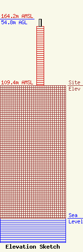
Site Elevation: 109.4 meters (359 ft) |
| Height of Structure: 48.7 meters (160 feet) |
| Overall Height Above Ground: 54.8 meters (180 feet) |
| Overall Height Above Mean Sea Level: 164.2 meters (539 feet) |
| Owner Info | East Texas Broadcasting, Inc.
PO Box 990
Mount Pleasant, TX 75456
(903) 572-8726
bud@easttexasradio.com |
| Contact Info | East Texas Broadcasting, Inc.
PO Box 990
Mount Pleasant, TX 75456
Bud Kitchens
(903) 572-8726
bud@easttexasradio.com |
