|
|
Antenna Structure Registration 1231632 |
 |
Registration Info | Registration Number: 1231632 |
| File Number: A0787113 |
| FAA Study: 2004-ANM-238-OE |
| FAA Issue Date: 03/10/2004 |
| Status: Constructed |
| Date Constructed: 09/01/1996 |
| FAA EMI: N |
| NEPA: N |
Structure Info
| Structure Type: TOWER |
| Structure Coordinates: 39-36-27.7 N 104-19-43.8 W (NAD 83) |
| Structure Coordinates: 39-36-27.8 N 104-19-41.9 W (Converted to NAD 27) |
| Structure Address: Nine Miles South Of Strasburg |
| Structure City: Strasburg, CO |
| Structure County: Arapahoe County |
| Painting & Lighting Info |
FAA Circular #: 70/7460-1G |
FAA Chapters: 3, 4, 5, 9 |
| Elevation Info |
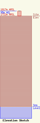
Site Elevation: 1722 meters (5650 ft) |
| Height of Structure: 94 meters (308 feet) |
| Overall Height Above Ground: 95 meters (312 feet) |
| Overall Height Above Mean Sea Level: 1817 meters (5961 feet) |
| Owner Info | KAGM-FM Joint Venture
64 On The Harbor Drive
Mt. Pleasant, SC 29464
(843) 606-2012
andrew@guest-radio.com |
| Contact Info | Fletcher, Heald & Hildreth, PLC
1300 North 17th Street, 11th Floor
Arlington, VA 22209
Kathleen Victory
(703) 812-0473
victory@fhhlaw.com |
