|
|
Antenna Structure Registration 1231991 |
 |
Registration Info | Registration Number: 1231991 |
| File Number: A0622128 |
| FAA Study: 01-ASW-7476-OE |
| FAA Issue Date: 01/11/2002 |
| Status: Terminated |
| Date Constructed: 09/30/1996 |
| FAA EMI: N |
| NEPA: N |
Structure Info
| Structure Type: MAST |
| Structure Coordinates: 34-44-26.0 N 92-22-7.4 W (NAD 83) |
| Structure Coordinates: 34-44-25.7 N 92-22-06.8 W (Converted to NAD 27) |
| Structure Address: 8424 West 12th Street |
| Structure City: Little Rock, AR |
| Structure County: Pulaski County |
| Painting & Lighting Info |
FAA Chapters: NONE |
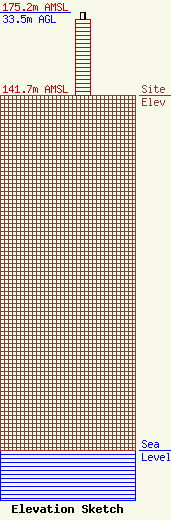
| Elevation Info |
Site Elevation: 141.7 meters (465 ft) |
| Height of Structure: 30.4 meters (100 feet) |
| Overall Height Above Ground: 33.5 meters (110 feet) |
| Overall Height Above Mean Sea Level: 175.2 meters (575 feet) |
| Owner Info | Alltel Cellular Associates of Arkansas Limited Partnership
1120 Sanctuary Pkwy #150 GASAREG
Alpharetta, GA 30009-7630
(770) 797-1070
Network.Regulatory@VerizonWireless.com |
| Contact Info | Verizon Wireless
1120 Sanctuary Pkwy #150 GASAREG
Alpharetta, GA 30009-7630
Jerri Janjua
(770) 797-1070
Network.Regulatory@VerizonWireless.com |
