|
|
Antenna Structure Registration 1232701 |
 |
Registration Info | Registration Number: 1232701 |
| File Number: A0732366 |
| FAA Study: 01-ANE-1030-OE |
| FAA Issue Date: 12/12/2001 |
| Status: Constructed |
| Date Constructed: 08/15/2002 |
| FAA EMI: N |
| NEPA: N |
Structure Info
| Structure Type: TOWER |
| Structure Coordinates: 41-27-43.2 N 72-1-25.0 W (NAD 83) |
| Structure Coordinates: 41-27-42.8 N 72-01-26.7 W (Converted to NAD 27) |
| Structure Address: 889r Colonel Ledyard Highway |
| Structure City: Ledyard, CT |
| Structure County: New London County |
| Painting & Lighting Info |
FAA Circular #: 70/7460-1K |
FAA Chapters: 3, 4, 5, 12 |
Remarks: Removed expiration date from determination. Scenario 1./jjs/case#635066 |
Remarks: SUPPLEMENTAL NOTICE STATES STRUCTURE REACHED GREATEST HEIGHT ON 01/28/2002 |
Remarks: Removed expiration date from determination. Scenario 1./jjs/case#635066 |
Remarks: SUPPLEMENTAL NOTICE STATES STRUCTURE REACHED GREATEST HEIGHT ON 01/28/2002 |
| Elevation Info |
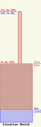
Site Elevation: 94.8 meters (311 ft) |
| Height of Structure: 105.8 meters (347 feet) |
| Overall Height Above Ground: 106.7 meters (350 feet) |
| Overall Height Above Mean Sea Level: 201.5 meters (661 feet) |
| Owner Info | Red Wolf Broadcasting Corporation
756 Colonel Ledyard Highway
357
Ledyard, CT 06339
(860) 464-1065
|
| Info |
