|
|
Antenna Structure Registration 1233123 |
 |
Registration Info | Registration Number: 1233123 |
| File Number: A1243735 |
| FAA Study: 2021-ASW-7647-OE |
| FAA Issue Date: 10/22/2021 |
| Status: Granted |
| Date Constructed: 03/19/2002 |
| NEPA: N |
Structure Info
| Structure Type: LTOWER |
| Structure Coordinates: 32-56-29.9 N 103-19-10.3 W (NAD 83) |
| Structure Coordinates: 32-56-29.5 N 103-19-08.5 W (Converted to NAD 27) |
| Structure Address: Country Club Road |
| Structure City: Lovington, NM |
| Structure County: Lea County |
| Painting & Lighting Info |
FCC Paragraph(s): 1, 3, 11, 21 |
Remarks: Continue As Is OM&L = PAINT/RED LIGHTS |
Remarks: PRIOR STUDY 2002-ASW-466-OE |
Remarks: Continue As Is OM&L = PAINT/RED LIGHTS |
Remarks: PRIOR STUDY 2002-ASW-466-OE |
| Elevation Info |
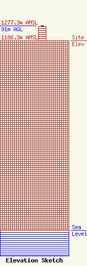
Site Elevation: 1186.3 meters (3892 ft) |
| Height of Structure: 90 meters (295 feet) |
| Overall Height Above Ground: 91 meters (299 feet) |
| Overall Height Above Mean Sea Level: 1277.3 meters (4191 feet) |
| Owner Info | MTD Inc.
717 S. Country Club
Lovington, NM 88260
(575) 396-0499
will@mtdradio.com |
| Info |
