|
|
Antenna Structure Registration 1233434 |
 |
Registration Info | Registration Number: 1233434 |
| File Number: A1380987 |
| FAA Study: 02-ASW-1582-OE |
| FAA Issue Date: 04/03/2002 |
| Status: Constructed |
| Date Constructed: 03/25/2002 |
| FAA EMI: N |
| NEPA: N |
Structure Info
|
| Structure Coordinates: 34-44-33.0 N 92-16-52.0 W (NAD 83) |
| Structure Coordinates: 34-44-32.7 N 92-16-51.5 W (Converted to NAD 27) |
| Structure Address: Little Rock |
| Structure City: Little Rock, AR |
| Structure County: Pulaski County |
| Painting & Lighting Info |
FAA Chapters: NONE |
| Elevation Info |
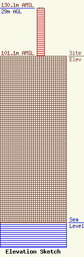
Site Elevation: 101.1 meters (332 ft) |
| Height of Structure: 29 meters (95 feet) |
| Overall Height Above Ground: 29 meters (95 feet) |
| Overall Height Above Mean Sea Level: 130.1 meters (427 feet) |
| Owner Info | Cape Publications, Inc.
8401 Greensboro Drive
McLean, VA 22102
(703) 873-6600
lawdept@tegna.com |
| Contact Info | TEGNA Inc.
8401 Greensboro Drive
McLean, VA 22102
Denise Branson
(703) 873-6606
dbranson@tegna.com |
