|
|
Antenna Structure Registration 1233562 |
 |
Registration Info | Registration Number: 1233562 |
| File Number: A0257435 |
| FAA Study: 92-AGL-1103-OE |
| FAA Issue Date: 09/01/1992 |
| Status: Constructed |
| Date Constructed: 06/15/1994 |
| FAA EMI: N |
| NEPA: N |
Structure Info
| Structure Type: TOWER |
| Structure Coordinates: 41-3-18.2 N 81-31-34.4 W (NAD 83) |
| Structure Coordinates: 41-03-18.0 N 81-31-35.0 W (Converted to NAD 27) |
| Structure Address: 65 Steiner Ave. |
| Structure City: Akron, OH |
| Structure County: Summit County |
| Painting & Lighting Info |
FAA Chapters: NONE |
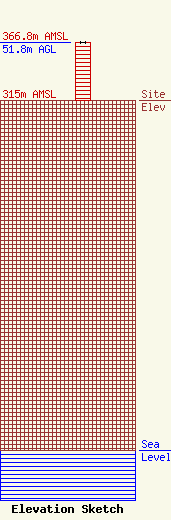
| Elevation Info |
Site Elevation: 315 meters (1033 ft) |
| Height of Structure: 51.8 meters (170 feet) |
| Overall Height Above Ground: 51.8 meters (170 feet) |
| Overall Height Above Mean Sea Level: 366.8 meters (1203 feet) |
| Owner Info | Board of Education, Akron City School District
65 Steiner Ave.
Akron, OH 44301
(330) 761-3098
|
| Contact Info | Carl E. Smith Consulting Engineers
2324 N. Cleveland-Massillon Rd.
807
Bath, OH 44210-0807
Roy Stype
(330) 659-4440
|
