|
|
Antenna Structure Registration 1233643 |
 |
Registration Info | Registration Number: 1233643 |
| File Number: A0258441 |
| FAA Study: 88-ACE-0601-OE |
| FAA Issue Date: 09/20/1988 |
| Status: Granted |
| NEPA: N |
Structure Info
| Structure Type: BTWR |
| Structure Coordinates: 41-35-13.0 N 93-37-34.0 W (NAD 83) |
| Structure Coordinates: 41-35-13.0 N 93-37-33.2 W (Converted to NAD 27) |
| Structure Address: 666 Grand Ave. |
| Structure City: Des Moines, IA |
| Structure County: Polk County |
| Painting & Lighting Info |
FAA Circular #: 70/7460-1G |
FAA Chapters: 4, 5, 9 |
| Elevation Info |
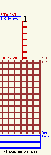
Site Elevation: 248.1 meters (814 ft) |
| Height of Structure: 129.5 meters (425 feet) |
| Overall Height Above Ground: 146.9 meters (482 feet) |
| Overall Height Above Mean Sea Level: 395 meters (1296 feet) |
| Owner Info | Ruan Center Corporation
666 Grand Ave.
Des Moines, IA 50309
John Ruan
(515) 245-5395
abrooks@ruan.com |
| Info |
