|
|
Antenna Structure Registration 1234294 |
 |
Registration Info | Registration Number: 1234294 |
| File Number: A0402055 |
| FAA Study: 02-AWP-1284-OE |
| Status: Constructed |
| Date Constructed: 05/31/2003 |
| FAA EMI: N |
| NEPA: N |
Structure Info
| Structure Type: TOWER |
| Structure Coordinates: 36-0-31.0 N 115-0-20.0 W (NAD 83) |
| Structure Coordinates: 36-00-31.1 N 115-00-17.0 W (Converted to NAD 27) |
| Structure Address: 2.2 Miles West Of Henderson, Nv, On Black Mountain |
| Structure City: Henderson, NV |
| Structure County: Clark County |
| Painting & Lighting Info |
FAA Circular #: 70/7460-1K |
FAA Chapters: 4, 8, 12 |
| Elevation Info |
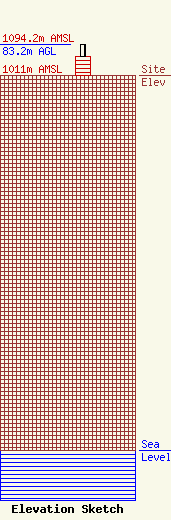
Site Elevation: 1011 meters (3317 ft) |
| Height of Structure: 50.3 meters (165 feet) |
| Overall Height Above Ground: 83.2 meters (273 feet) |
| Overall Height Above Mean Sea Level: 1094.2 meters (3590 feet) |
| Owner Info | VALLEY BROADCASTING CO.
1500 FOREMASTER LANE
LAS VEGAS, NV 89101
(702) 657-3257
mguranik@kvbc.com |
| Contact Info | PARADIGM ASSOCIATES, INC.
8620 N. NEW BRAUNFELS, SUITE 305
SAN ANTONIO, TX 78217
GARY KEENER
(210) 828-4555
gkeener@pdigm-inc.com |
