|
|
Antenna Structure Registration 1235050 |
 |
Registration Info | Registration Number: 1235050 |
| File Number: A0922170 |
| FAA Study: 2013-ANM-1306-OE |
| FAA Issue Date: 09/03/2013 |
| Status: Constructed |
| Date Constructed: 08/01/2002 |
| FAA EMI: N |
| NEPA: N |
Structure Info
| Structure Type: LTOWER |
| Structure Coordinates: 46-31-56.5 N 120-30-47.6 W (NAD 83) |
| Structure Coordinates: 46-31-57.0 N 120-30-43.4 W (Converted to NAD 27) |
| Structure Address: Ahtaneum Ridge, 6.95 Km South Of |
| Structure City: Yakima, WA |
| Structure County: Yakima County |
| Painting & Lighting Info |
FAA Chapters: NONE |
Remarks: PRIOR STUDY 1995-ANM-351-OE |
| Elevation Info |
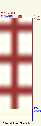
Site Elevation: 602 meters (1975 ft) |
| Height of Structure: 15.2 meters (50 feet) |
| Overall Height Above Ground: 20.1 meters (66 feet) |
| Overall Height Above Mean Sea Level: 622.1 meters (2041 feet) |
| Owner Info | Washington State University
642530
Pullman, WA 99164-2530
(509) 335-4962
tsaylor@wsu.edu |
| Contact Info | Washington State University
642530
Pullman, WA 99164-2530
Thomas Saylor
(509) 335-4962
tsaylor@wsu.edu |
