|
|
Antenna Structure Registration 1235168 |
 |
Registration Info | Registration Number: 1235168 |
| File Number: A0331089 |
| FAA Study: 02-ASO-2913-OE |
| FAA Issue Date: 07/08/2002 |
| Status: Constructed |
| Date Constructed: 09/27/2002 |
| FAA EMI: N |
| NEPA: N |
Structure Info
| Structure Type: TOWER |
| Structure Coordinates: 35-56-44.0 N 83-34-51.0 W (NAD 83) |
| Structure Coordinates: 35-56-43.7 N 83-34-51.4 W (Converted to NAD 27) |
| Structure Address: Kyker Ferry Rd |
| Structure City: Kodak, TN |
| Structure County: Sevier County |
| Painting & Lighting Info |
FAA Circular #: 70/7460-1K |
FAA Chapters: 3, 4, 5, 12 |
Remarks: Removed expiration date from determination. Scenario 1./jjs/case#635066 |
Remarks: SUPPLEMENTAL NOTICE STATES STRUCTURE REACHED GREATEST HEIGHT ON 09/16/2002 |
| Elevation Info |
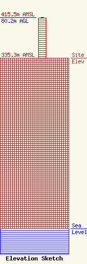
Site Elevation: 335.3 meters (1100 ft) |
| Height of Structure: 79.2 meters (260 feet) |
| Overall Height Above Ground: 80.2 meters (263 feet) |
| Overall Height Above Mean Sea Level: 415.5 meters (1363 feet) |
| Owner Info | VOLUNTEER CHRISTIAN TELEVISION, INC.
6922 142ND AVE
LARGO, FL 33771-4722
(727) 535-5622
DANDREA@CTNONLINE.COM |
