|
|
Antenna Structure Registration 1236195 |
 |
Registration Info | Registration Number: 1236195 |
| File Number: A1022117 |
| FAA Study: 2002-AWP-2640-OE |
| FAA Issue Date: 09/26/2002 |
| Status: Constructed |
| Date Constructed: 01/03/2003 |
| FAA EMI: N |
| NEPA: N |
Structure Info
| Structure Type: POLE |
| Structure Coordinates: 34-8-34.1 N 118-1-57.2 W (NAD 83) |
| Structure Coordinates: 34-08-34.1 N 118-01-54.0 W (Converted to NAD 27) |
| Structure Address: 21 W. Santa Clara Street |
| Structure City: Arcadia, CA |
| Structure County: Los Angeles County |
| Painting & Lighting Info |
FAA Chapters: NONE |
Remarks: Removed expiration date from determination. Scenario 1./jjs/case#635066 |
| Elevation Info |
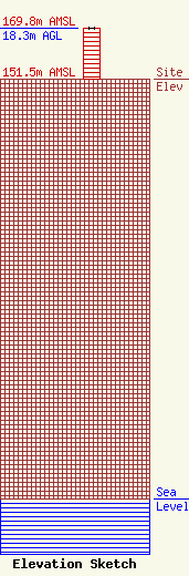
Site Elevation: 151.5 meters (497 ft) |
| Height of Structure: 18.3 meters (60 feet) |
| Overall Height Above Ground: 18.3 meters (60 feet) |
| Overall Height Above Mean Sea Level: 169.8 meters (557 feet) |
| Owner Info | T-Mobile West Tower LLC
12920 SE 38th Street
Bellevue, WA 98006
(425) 383-8401
FCCRegulatoryComplianceContact@T-Mobile.com |
| Contact Info | Crown Castle
2000 Corporate Drive
Canonsburg, PA 15317
Don Snyder
(724) 416-2470
Don.Snyder@crowncastle.com |
