|
|
Antenna Structure Registration 1236206 |
 |
Registration Info | Registration Number: 1236206 |
| File Number: A1217404 |
| FAA Study: 2002-ACE-1154-OE |
| FAA Issue Date: 08/30/2002 |
| Status: Constructed |
| Date Constructed: 12/06/2005 |
| FAA EMI: N |
| NEPA: N |
Structure Info
|
| Structure Coordinates: 37-5-49.2 N 94-34-25.8 W (NAD 83) |
| Structure Coordinates: 37-05-49.0 N 94-34-25.0 W (Converted to NAD 27) |
| Structure Address: 0.43 Km South Of Highway P, 1.87 Km West Of Joplin City Limits |
| Structure City: Joplin, MO |
| Structure County: Jasper County |
| Painting & Lighting Info |
FAA Circular #: 70/7460-1K |
FAA Chapters: 3, 4, 5, 12 |
Remarks: Removed expiration and final dates from determination. Scenario 2./jjs/case#635066 |
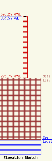
| Elevation Info |
Site Elevation: 295.7 meters (970 ft) |
| Height of Structure: 299.6 meters (983 feet) |
| Overall Height Above Ground: 300.5 meters (986 feet) |
| Overall Height Above Mean Sea Level: 596.2 meters (1956 feet) |
| Owner Info | Zimmer Radio, Inc.
325 S. Kingshighway - Ste B
Gape Girardeau, MO 63703-5701
(573) 334-7474
james@zrimarketing.com |
| Contact Info | Fletcher, Heald & Hildreth, PLC
1300 North 17th St., 11th FL
Arlington, VA 22209
Kathleen Victory
(703) 812-0400
victory@fhhlaw.com |
