|
|
Antenna Structure Registration 1237322 |
 |
Registration Info | Registration Number: 1237322 |
| File Number: A0557709 |
| FAA Study: 2007-ASW-6437-OE |
| FAA Issue Date: 07/27/2007 |
| Status: Constructed |
| Date Constructed: 01/20/2003 |
| FAA EMI: N |
| NEPA: N |
Structure Info
| Structure Type: POLE |
| Structure Coordinates: 34-40-10.9 N 92-29-46.4 W (NAD 83) |
| Structure Coordinates: 34-40-10.6 N 92-29-45.8 W (Converted to NAD 27) |
| Structure Address: 236 East Crestside Drive |
| Structure City: Alexander, AR |
| Structure County: Saline County |
| Painting & Lighting Info |
FAA Chapters: NONE |
Remarks: PRIOR STUDY 2003-ASW-224-OE |
| Elevation Info |
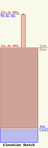
Site Elevation: 141.4 meters (464 ft) |
| Height of Structure: 58 meters (190 feet) |
| Overall Height Above Ground: 58.8 meters (193 feet) |
| Overall Height Above Mean Sea Level: 200.2 meters (657 feet) |
| Owner Info | SBA Towers II LLC
8051 Congress Avenue
Boca Raton, FL 33487
(561) 995-7670
ERoach@sbasite.com |
| Contact Info | SBA Towers II LLC
8051 Congress Avenue
Boca Raton, FL 33487
Edward Roach
(561) 995-7670
ERoach@sbasite.com |
