|
|
Antenna Structure Registration 1237735 |
 |
Registration Info | Registration Number: 1237735 |
| File Number: A1230574 |
| FAA Study: 2021-ASW-22910-OE |
| FAA Issue Date: 09/06/2022 |
| Status: Constructed |
| Date Constructed: 03/14/2003 |
| NEPA: N |
Structure Info
| Structure Type: MTOWER |
| Structure Coordinates: 34-49-21.2 N 92-22-54.9 W (NAD 83) |
| Structure Coordinates: 34-49-20.9 N 92-22-54.3 W (Converted to NAD 27) |
| Structure Address: 7100 Counts Massie Rd (ar20464-a) |
| Structure City: Maumelle, AR |
| Structure County: Pulaski County |
| Painting & Lighting Info |
FAA Chapters: NONE |
Remarks: PRIOR STUDY 2002-ASW-4607-OE |
| Elevation Info |
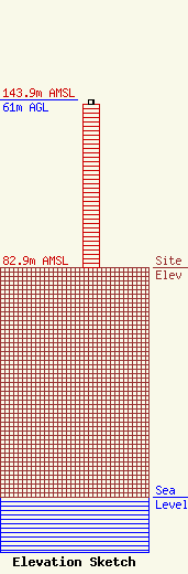
Site Elevation: 82.9 meters (272 ft) |
| Height of Structure: 59.4 meters (195 feet) |
| Overall Height Above Ground: 61 meters (200 feet) |
| Overall Height Above Mean Sea Level: 143.9 meters (472 feet) |
| Owner Info | SBA Structures, LLC
8051 Congress Avenue
Boca Raton, FL 33487
(561) 995-7670
ERoach@sbasite.com |
| Contact Info | SBA Structures, LLC
8051 Congress Avenue
Boca Raton, FL 33487
(561) 995-7670
ERoach@sbasite.com |
